
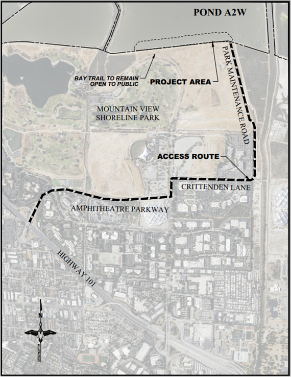
Trail Interruptions in Shoreline Park
The U.S. Fish and Wildlife Service and the California State Coastal Conservancy is continuing soil hauling for the South Bay Salt Pond Restoration Project at Shoreline Park. Because this utilizes free dirt as it becomes available, it is intermittent, but the trail remains open at all times. This project will provide important sea level rise and habitat restoration benefits. As part of the project, soil hauling will continue for the next several months.
Between 7:30 a.m. and 4 p.m. on weekdays, visitors to Shoreline Park and on Stevens Creek and Bay Trails may experience daily interruptions and brief closures of public access trail crossings for delivery of project materials.
For more project details, visit the Mountain View Trails Visitor Information page and scroll to the bottom.
VISION: Welcoming trails and healthy wildlife corridors that connect people from the bay to the mountains in the Stevens Creek and Permanente Creek watersheds.
The Friends of Stevens Creek Trail is a local community group whose goal is to raise community awareness and support for the completion of a trail in the Stevens Creek Corridor. Founded in December of 1992 to support on-going local government efforts, the Friends was incorporated as a 501(c)3 public benefit non-profit corporation in March of 1993. This grassroots community action group is endorsed by the Santa Clara County Board of Supervisors and by the Cities of Cupertino, Mountain View, and Los Altos.
The Board of Directors of the Friends of Stevens Creek Trail is made up of volunteer community members from the communities that the creek runs through on its way to the bay. Meet the Board
The Friends Volunteer Action Team runs community outreach
and education programs, organizes tree plantings and trail work
days, and raises funds for enhancements of the trail, as well
as hosting the annual Trailblazer Race.
Take a look at the list of great folks who have been past recipients of our
Volunteer Of The Year award.
To sponsor us or be part of the Trail Action Team or for more information:

Stevens Creek is named after Capt. Elisha Stephens, one of the early settlers of Cupertino.
Stevens Creek is one of the most natural creeks in the San Francisco Bay Area. Beginning on the flanks of Black Mountain in the Santa Cruz Mountains, it flows through Stevens Canyon and then through Cupertino, Los Altos, Sunnyvale, and Mountain View, on its way to join the San Francisco Bay.
In Santa Clara County and in Cupertino, Stevens Creek flows northeast from the 1000-acre Stevens Creek County Park, through Deep Cliff Golf Course, McClellan Ranch Park, and Blackberry Farm Golf Course. From there the Creek forms the border between Los Altos and Sunnyvale. In Mountain View it runs roughly parallel to Highway 85 until it reaches Highway 101 where it flows into the Bay between Moffett Field to the south and Shoreline Park to the north. The total length of Stevens Creek is more than 20 miles.
Permanente Creek parallels Stevens Creek and shares a similar route. Historically the two creeks have intermingled. As its name implies, Permanente Creek runs year round most years, though with lowered groundwater levels in the past century, it goes underground before reaching the bay.
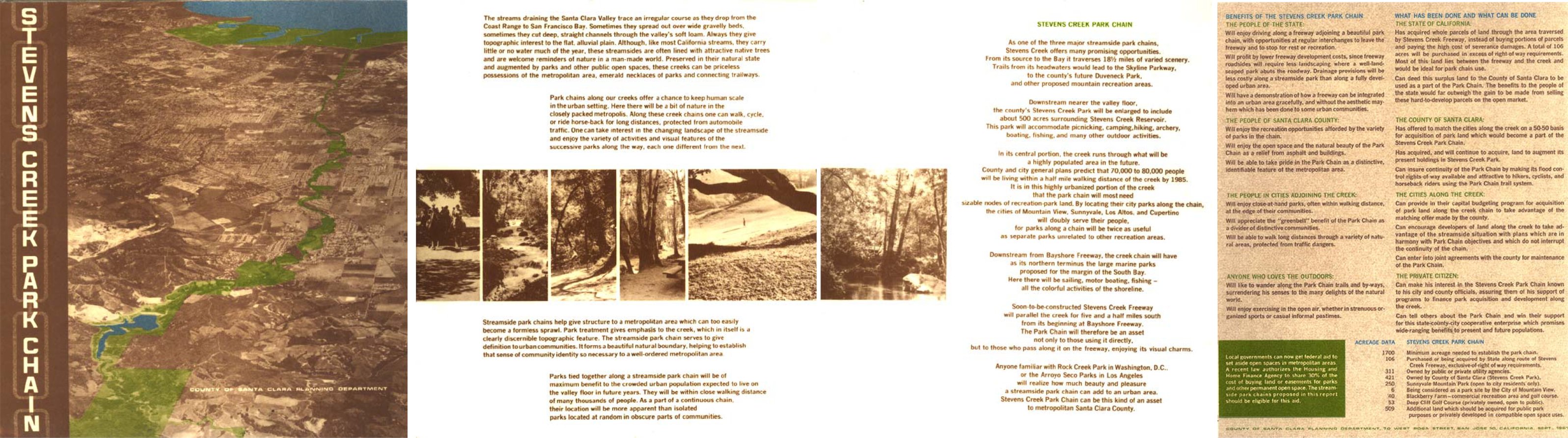
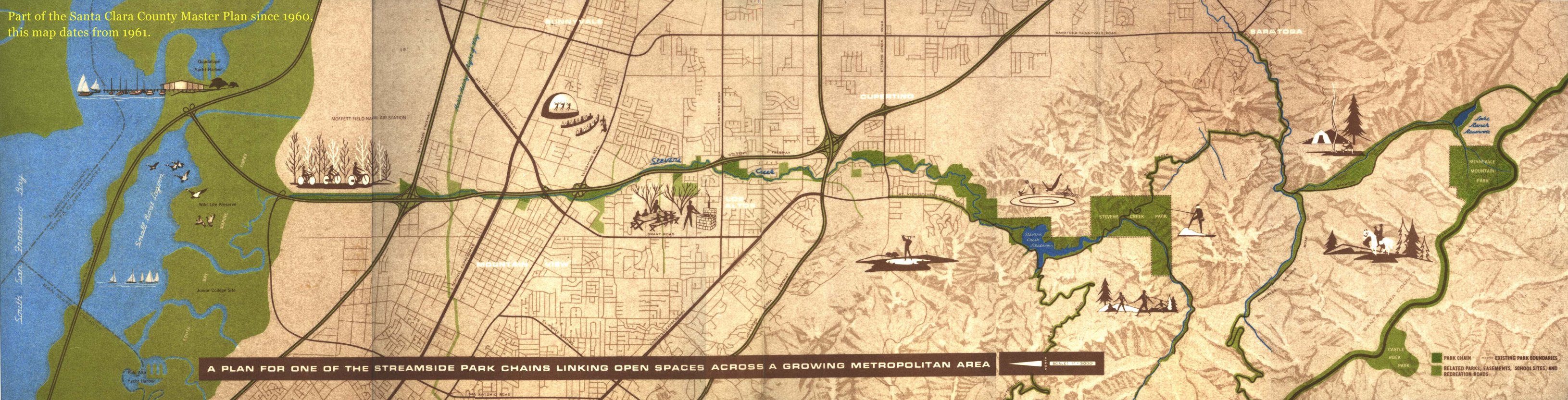
For over 50 years, a multi-use trail has been envisioned along the creek corridor of Stevens Creek. The cities and the counties have wisely reserved over 100 acres along the creek for public access, and have rejected previous plans to replace the natural creek bed with a cemented channel.
In 1961 a brochure was even published by Santa Clara County describing the "Stevens Creek Park Chain" and showing much of the route on the land as it still exists today. This accompanied the construction of Highway 85 between Hwy 101 in Mountain View and Hwy 280 in Cupertino.
The trail runs through tidal marshlands and natural riparian habitats, providing for recreation and educational opportunities. The trail is regularly used for bicycling, bird watching, commuting, dog walking, education, hiking, jogging, nature walks, running, scootering, roller and inline skating, skateboarding, striding, and walking.
The trail in Mountain View extends south from its connection to the Bay Trail in Shoreline park, past La Avenida trailhead, under Highway 101, past Whisman School and Park, under Middlefield Rd., past Creekside Park, under Hwy 85, over Central Expressway, past Landel's School over Highway 237 past the Yuba Drive trailhead, under El Camino Real, through a large meadow, past an access point at Sleeper Avenue, then over Hwy 85 to where it now ends at the corner of Dale Avenue and Heatherstone Way. Together with the city of Sunnyvale, work is underway to extend the trail South to Fremont Ave.
With the spring 2021 addition of 0.3 miles of trail, Cupertino now has 1.3 continuous miles of Stevens Creek trail following the creek from Linda Vista Park to Stevens Creek Boulevard. The trail follows Stevens Creek through open space from Linda Vista Park north through the McClellan Ranch Preserve, Blackberry Farm Park, and the old Stocklmeir property to Stevens Creek Blvd. Along the way, the gravel and permeable concrete trail passes by areas of habitat restoration, the 4-H farm and community gardens of McClellan Ranch Preserve.
For the latest developments, please check our trail update page.
Stevens Creek is home to a host of native California wildlife. Raccoons, opossums, quail, hawks, swallows, jays, and many others make their home in the creek corridor or use it as a greenbelt thoroughfare for traveling to and from distant feeding areas. Trail plans stress the importance of restoring and preserving the creek's natural environment. This includes planting native vegetation to protect existing wildlife habitats and to provide wildlife with additional sources of food and shelter.
The Stevens Creek Trail provides access
to the creek and, eventually to hundreds of acres of adjacent
open space. It is available for hiking, jogging, cycling, and
other recreational activities which easily integrate with the
natural environment.
Read more about the benefits of trails...
The safe, automobile-free route links neighborhoods, local parks, schools, and businesses including Rancho San Antonio, Monte Bello Open Space Preserve, Stevens Creek County Park, McClellan Ranch, Stevens Creek Shoreline Nature Study Area and Shoreline Park. The Trail offers residents an alternative transportation corridor to avoid the congestion and pollution of the region's highways. The proposed trail is through Cupertino, Los Altos, Sunnyvale, and Mountain View. It already connects to Cal Train and the Light Rail System in Mountain View. The Shoreline Business Park, commercial areas in Cupertino, and other business areas near the Trail employ over 30,000 people.
Outstanding environmental education opportunities for the community at large exist in the creek corridor. School children from four schools directly on the creek and the 12 schools within a mile of the creek will have safe access for hands-on nature study. School children will also be invited to participate in trail days to plant native vegetation, and to creek cleanup days. The opportunity also exists to adopt a portion of the Trail. Tours will be regularly available to familiarize the community with the rare riparian habitat provided by Stevens Creek.
Representatives from each of the school districts and the Environmental Volunteers, a non-profit environmental education organization, serve on the Advisory Council of the Friends. They are working together to tailor their curricula to take advantage of the enhanced access to the creek.
The Stevens Creek Trail route travels through four cities and many neighborhoods, business centers, and school grounds. Over 40,000 people live within walking distance of the Trail. The 30,000 who work near the creek can also benefit from access to the Trail for lunch breaks, alternate transportation, and opportunities to relax in natural environments.
Explore the interactive map in the full window. or get the app on your IOS or Android phone
Comments, Questions, Suggestions?
