|
Working Group |
|
|
|
|
County |
Joint Cities Working Group |
Back to Top | ||||
Background InformationThe Joint Cities Working Group was formed following the Los Altos Stevens Creek Trail Feasibility Study when it became evident that most of the remaining trail would need to be built using land from more than a single city. In fact, the preferred alignment from the Los Altos study began and ran in Mountain View before crossing through a portion of Sunnyvale and finally entering Los Altos. The JCWG was composed of 2 sub-groups. The first of these, the Joint Cities Working Team (JCWT) was composed of one city council member appointed from each city and one staff member from each city. The second sub-group, the Citizens Working Group (CWG) was composed of 3 (later 4) citizens from each of the 4 cities selected by the JCWT. Additional representatives from Santa Clara County Parks and Santa Clara Valley Water District attended most meetings. Joint Cities Working Group StatusThe crowning achievement of the Joint Cities Working Group was a feasibility study, published in September 2015, for completing the Stevens Creek Trail between Dale/Heatherstone in Mountain View and Stevens Creek Blvd. in Cupertino. The full feasibility study and associated public comments received are available at the JCWG Website. All the documents relating to the study were also published as part of a Mountain View City Council Study Session held 2015-12-01 as Item 3.1 which you can find here (as a backup location). The study itself does not make any recommendation for what route the trail should take - only evaluating the feasibility of many possible routes. After the initial draft of the study was made available, a series of 3 public meetings were held in May and June of 2015 to collect comments on the study and the possible routes. The Citizens Working Group then created a set of Recommendations to the Joint Cities Working Team (available at the above link). for routing the trail and other future actions to take. Following that, the Joint Cities Working Team met to produce its own set of Recommendations to the City Councils. Over the remainder of 2015 through June 2016, all 4 cities accepted the feasibility study and JCWT recommendations. On September 29, 2016, the Joint Cities Working Team officially voted to disband, passing responsibilites to staff and BPACs of the individual cities to carry on the work. |
|||||
|
Working Group |
|
|
|
|
County |
Mountain View Status |
Back to Top |
||||
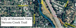
Existing TrailThe 4.8 mile segment within Mountain View, with several underpasses
and overpasses, is estimated to have cost over $17 million.
The city completed the seventh trail section in 2012 when it extended the trail
from Sleeper Avenue
across Highway 85 to the corner of Dale Ave and Heatherstone Way. The final Mountain View segment, Reach 4 Segment 2, has been planned to be built in three phases/sections. Funding, design and construction will happen in pieces, as discussed below. El Camino to Sleeper (Phase I):This first phase is the already completed 3/4 mile section to Sleeper Aveunue. This opened in June 2009. Sleeper over Hwy85 to Dale/Heatherstone (Phase II):
This second phase opened in June 2012.
It is a short extension that crosses Hwy 85 to bring the trail to the corner of
Dale Ave. and Heatherstone Way on the east side of Hwy 85.
|
|||||
This is an aerial photo/map of the new trail, shown in orange.(498kB) |
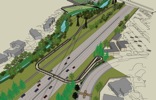
Computer rendering of trail between Sleeper Ave and Dale Ave - Heatherstone Way (351kB) |
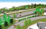
Computer rendering of trail between Sleeper Ave and Dale Ave, showing mitigation trees (411kB) | |||
Dale/Heatherstone to Mountain View High School: (Phase III)
This final 1.0 mile segment
would extend the trail south to Mountain View High School near the
Los Altos-Mountain View border.
As a result of the coordinated effort of Mountain View, Sunnyvale, Los Altos and Cupertino that culminated in
a "Joint Cities Stevens Creek Trail Feasibility Study" in 2015 and approved by all 4 cities in 2016,
this next segment will now extend further, to Fremont Avenue, with additional access at Remington Ave.
Current cost estimate is approximately $13M.
Design work has been funded (through VTA Measure B and city matching funds) and will began in 2022.
Construction work will be decided and funded during or after the latter stages of design work.
Meanwhile, Sunnyvale has also secured funding from VTA Measure B and approved matching funds to begin work
on design of the continuing portion of trail from Remington Drive to Fremont Ave.
See an early overall Map (5.4 MB PDF) More Information?Want to hear the latest about Stevens Creek Trail in Mountain View from us? Sign up on our Mountain View email alert list to receive email when a signficant event will be happening. For specific information about the trail in Mountain View,call the Mountain View Public Works Department at (650) 903-6311. Also, MV Parks and Rec maintains a Trail Closure Hotline at 650-903-6072, a recorded announcement with up-to-date info, especially during storm conditions that might necessitate a closure or check their website. |
|||||
|
Working Group |
|
|
|
|
County |
Cupertino Status |
Back to Top |
||||
|
Stevens Creek is one of several creeks that flow through the city of Cupertino. The City of Cupertino is responsible for the portion of Stevens Creek within its city limits, extending from parts of Homestead Rd., at the border with Sunnyvale and Los Altos, up through Blackberry Farm and into the foothills of the Santa Cruz Mountains meeting with Santa Clara County Parkland. Cupertino has done work on the Stevens Creek Trail in this area under the umbrella of the Stevens Creek Corridor Project. Phase 1 opened on July 4th, 2009 with a celebration of a renovated Blackberry Farm and a ceremony for Cupertino's first section of the Stevens Creek Trail: 0.7 miles of permeable concreate running north along the creek from McClellan Road through the McClellan Ranch Nature Preserve, then ending at BlackBerry Farm. Phase 2 began in 2011 and opened another 0.3 mile section of the trail in 2014, continuing from Blackberry Farm Park, along the edge of Blackberry Farm Golf Course, through the city-owned Stocklmeir property, and ending at Stevens Creek Blvd., as shown on their map. Phase 2 also included other rehabilitation work at the Stocklmeir Property, and further restoration and realignment of the creek along the route. In June, 2021, the Stevens Creek Trail was extended 0.3 miles south from McClellan Road to Linda Vista Park using the former “Old Haul Road”. The former road once provided truck access to the quarries that existed upstream along Stevens Creek. The routing is along the eastern edge of Deep Cliff Golf Course. The extension was made possible by the generous donation of land by former Cupertino City Council member and Mayor Richard Lowenthal and his wife, Ellen (in 2020). Construction work was done by Redgwick Construction. The roadbed for the trail extension was graded and safety fencing was placed along the western trail edge. You can read more about it on the City of Cupertino's website. As of late 2022, a new trail segment begins at Varian Park and leads to a pre-existing “staircase” that descends to the banks of Stevens Creek. The path then proceeds under Stevens Creek Boulevard along the creek and up to the existing bike and pedestrian trail on the former Stocklmeir property that is now part of Blackberry Farm. Hikers and walkers are encouraged to try out the new path and help spread the word. The trail segment was made possible by the purchase of a privately-held parcel along Stevens Creek by former Cupertino Mayor and current Friends of Stevens Creek Trail Board Member Richard Lowenthal. He, along with a team of volunteers from Hewlett Packard, then cleared debris from an existing path to create the connection between two parks. The result is a 2-mile walkable trail that extends from Varian Park at the north end to Linda Vista Park on the south end. It traverses Blackberry Farm and McClellan Ranch Park, and passes alongside a beautiful portion of Deep Cliff golf course on the way. Rancho San AntonioOne possible route for the Stevens Creek Trail to connect from Cupertino to the cities to the north is through Rancho San Antonio to St. Joseph Ave in Los Altos. The Joint Cities Working Group feasibility study researched further a connection from the Snyder-Hammond Trail, over the Union Pacific Railroad tracks to Stevens Creek Blvd. This project was on Cupertino Capital Improvements Projects (CIP) list at one point, but has since been dropped. More Information?Want to hear the latest from us? Sign up on our Cupertino email alert list to receive email when a signficant event will be happening. |
|||||
|
Working Group |
|
|
|
|
County |
Sunnyvale Status |
Back to Top |
||||
|
Stevens Creek, east of Hwy 85, is the border between Sunnyvale and Mountain View. The section of the Trail on the Sunnyvale-Mountain View border will be constructed entirely within Mountain View. Mountain View will construct the portion from the corner of Dale Ave and Heatherstone Way to Mountain View High School. Then Sunnyvale will take over and construct the remainder of the trail down to Fremont Avenue. At this point, Sunnyvale is an enthusiastic supporter of the Joint Cities Working Group recommendation for Segment 1, to extend the trail south down to Fremont Avenue. In 2020, Sunnyvale secured funding from VTA Measure B and approved matching funds to begin work on design of the continuing portion of trail from Remington Drive (in Mountain View) to Fremont Avenue. A design architecture team was selected in early 2022. For additional project information, visit the Sunnyvale project page. More Information?Want to hear the latest from us? Sign up on our Sunnyvale email alert list to receive email when a signficant event will be happening. |
|||||
|
Working Group |
|
|
|
|
County |
Los Altos Status |
Back to Top |
||||
|
Perhaps motivated by a $5,000 contribution from the Friends of Stevens Creek Trail, Los Altos provided $20,000 in matching funds to secure a VTA grant for $80,000 towards a Stevens Creek Trail Feasibility Study. This began in May 2006. The money paid for a consultant, Alta Planning, to study the area. Two community meetings were held. The first comunity meeting, held in May 2007, gathered ideas from the public about what they would like to see in a trail, where they would like to go, and concerns about a trail in their neighborhood. The second comunity meeting, held in December 2007, shared with the public 5 possible trail alignments and gathered public opinion about each - both pro and con. The public was also asked to vote for their favorite alignment. The Los Altos feasibility study concluded in 2009 with a final report from the consultant and a recommendation for preferred alignment. However, since the preferred alignment included trail segments in Mountain View and Sunnyvale as well as Los Altos, and also ties into Cupertino, Los Altos proposed taking a 4-City regional planning approach to evaluating the trail prior to undertaking any more detailed design. Los Altos was an active participant in the Joint Cities Working Group and approved the final recommendations. Though none of the proposed trail will be built within Los Altos, the city will still gain 2 direct access points from Segment 1 that is, essentially, exactly the same as the northern portion of the route selected in their own Feasibility Study. These access points are from Bryant Avenue, just north of their border with Mountain View, and at Fremont Avenue, just east of their border with Sunnyvale. We are hopeful that Los Altos will recognize the value of this trail to its residents and will contribute materially to its construction so that it can be realized sooner. More Information?Want to hear the latest from us? Sign up on your Los Altos email alert list to receive email when a signficant event will be happening. |
|||||
|
Working Group |
|
|
|
|
County |
Santa Clara County |
Back to Top |
||||
|
In the county, most of the trail between Stevens Creek County Park (if that link doesn't work, start here ) and the top of the Santa Cruz Mountains is well-defined and partly completed. There are multiuse trails suitable for hikers, bikers, and equestrians. One section being developed is in Rancho San Antonio where the Stevens Creek Trail has been routed alongside Permanente Creek from the most southern parking lot to the Hammond-Snyder historical house. Unfortunately, due to the Southern Pacific Railroad Tracks that lead to the Lehigh Permanente Cement Plant, the trail has been cutoff from reaching Stevens Creek Boulevard. However, after years of being stalled, in May 2009, with the help of the Friends of Stevens Creek Trail, a meeting took place with Lehigh, UPRR, Cupertino, and Santa Clara Parks. What came out of this is that a grade level crossing cannot be added here, but an above grade (bridge) crossing looks quite possible and UPRR would even support that, if it were to allow removal of the existing grade crossing used for maintenance vehicles. Until such time as an easement across the Union Pacific Railroad Tracks is granted, this trail will simply be known as the "Hammond-Snyder Loop Trail". More details on this crossing are kept on a separate webpage. |
|||||